Santa Cruz County announced evacuation warnings Sunday for the San Lorenzo Valley area and the north coast ahead of a storm forecast to deliver up to 10 inches of rain in the Santa Cruz Mountains and potentially at rates that could trigger dangerous mud slides and debris flows, especially across the 86,000 acres burned by the CZU Lightning Complex in August.
A map posted on Community.Zonehaven.com allows you to view which zone you live in and determine whether it's under evacuation. You can use the controls on the left side of map to view the legend and view all recent wildfire incidents.
"An evacuation warning means these individuals need to be prepared to leave immediately with a go bag and planned evacuation route," Cal Fire said.
You can also sign up for text and email alerts at scr911.org.
Any mandatory evacuations would be issued 24 hours ahead of the storm, said Cal Fire Deputy Chief Nate Armstrong.
"Our primary objective is to get people out of the area so we don’t have to rescue them because there’s no stopping the debris flows," said Armstrong. "We’ve been working on early messaging for weeks and months and making sure people know they are in areas that have potential for debris flows. We’ve been telling them to have an evacuation plan, have your bags packed."
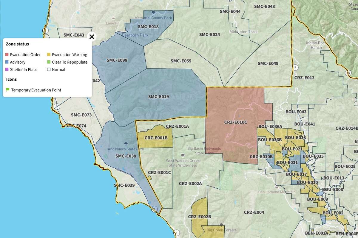
Cal Fire announced evacuation warnings Sunday evening for Santa Cruz County, comprising the San Lorenzo Valley area and the north coast of Santa Cruz County. The map at community.zonehaven.com shows which zones are under a warning.
community.zonehaven.comThe super soaker poised to arrive in the Bay Area Tuesday is an atmospheric river and is expected to be the wettest and strongest of the rainy season so far with the heaviest rainfall Tuesday night into Wednesday.
Atmospheric rivers pull long plumes of water vapor in the atmosphere — 250 to 375 miles wide on average — and are often referred to as rivers in the sky. On the West Coast, they most often originate in the South Pacific, and as they travel from the tropics across the ocean, they collect incredible amounts of moisture.
The weather service has calculated rainfall rate thresholds for the Santa Cruz Mountain region and determined that mud slides and debris flows could occur if rates reach 0.3 inch in 15 minutes, 0.5 inch in 30 minutes or 0.7 inch in 60 minutes.
"Areas of most concern in Santa Cruz are the two areas that have the highest burn severity at the headwaters of steep drainages that homes are below," said Armstrong. "That's Swanton Road on the north Santa Cruz County coast and the community of Boulder Creek especially as you move up the Highway 236 corridor."

Cal Fire announced evacuation warnings Sunday evening for Santa Cruz County, comprising the San Lorenzo Valley area and the north coast of Santa Cruz County. The map at community.zonehaven.com shows which zones are under a warning.
community.zonehaven.com"flow" - Google News
January 25, 2021 at 08:43PM
https://ift.tt/3qQeUK5
Map: Debris flow evacuations in Santa Cruz County - SF Gate
"flow" - Google News
https://ift.tt/2Sw6Z5O
https://ift.tt/2zNW3tO
Bagikan Berita Ini


0 Response to "Map: Debris flow evacuations in Santa Cruz County - SF Gate"
Post a Comment