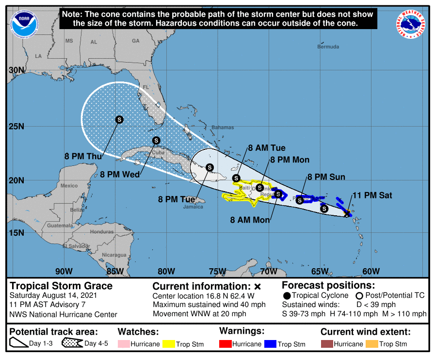
The slowing of Grace is a sign that it may begin to become better organized.
It could be in the Gulf of Mexico by late in the week.
Here is the text of the 10 p.m. advisory:
BULLETIN
Tropical Storm Grace Advisory Number 7
NWS National Hurricane Center Miami FL AL072021
1100 PM AST Sat Aug 14 2021
…POORLY ORGANIZED GRACE NOW MOVING A BIT SLOWER…
…HEAVY RAINFALL ACROSS THE LESSER AND GREATER ANTILLES REMAINS A
PRIMARY THREAT OVER THE NEXT FEW DAYS…
SUMMARY OF 1100 PM AST…0300 UTC…INFORMATION
———————————————–
LOCATION…16.8N 62.4W
ABOUT 170 MI…275 KM ESE OF ST. CROIX
ABOUT 265 MI…430 KM ESE OF SAN JUAN PUERTO RICO
MAXIMUM SUSTAINED WINDS…40 MPH…65 KM/H
PRESENT MOVEMENT…WNW OR 285 DEGREES AT 20 MPH…31 KM/H
MINIMUM CENTRAL PRESSURE…1010 MB…29.83 INCHES
WATCHES AND WARNINGS
——————–
CHANGES WITH THIS ADVISORY:
A Tropical Storm Watch has been issued for the entire coast of
Haiti.
The government of Antigua has discontinued the Tropical Storm
Warning for Antigua, Barbuda, Anguilla, St. Kitts and Nevis,
and Montserrat, and the British Virgin Islands.
SUMMARY OF WATCHES AND WARNINGS IN EFFECT:
A Tropical Storm Warning is in effect for…
* Saba and Sint Eustatius
* Sint Maarten
* St. Martin and St. Barthelemy
* U.S. Virgin Islands
* Puerto Rico, including Vieques and Culebra
* Dominican Republic from Cabo Caucedo to Samana
A Tropical Storm Watch is in effect for…
* South coast of the Dominican Republic from the Haitian border to
Cabo Caucedo
* North coast of the Dominican Republic from the Haitian border to
Samana
* Entire coast of Haiti
A Tropical Storm Warning means that tropical storm conditions are
expected somewhere within the warning area.
A Tropical Storm Watch means that tropical storm conditions are
possible within the watch area, generally within 48 hours.
Interests elsewhere in the Dominican Republic, Haiti, the Turks and
Caicos Islands, the southeastern Bahamas, and Cuba should monitor
the progress of Grace. Additional watches and warnings could be
required for this area tonight or on Sunday.
For storm information specific to your area in the United
States, including possible inland watches and warnings, please
monitor products issued by your local National Weather Service
forecast office. For storm information specific to your area
outside of the United States, please monitor products issued by
your national meteorological service.
DISCUSSION AND OUTLOOK
———————-
At 1100 PM AST (0300 UTC), the center of Tropical Storm Grace was
located near latitude 16.8 North, longitude 62.4 West. Grace is now
moving toward the west-northwest near 20 mph (31 km/h). A continued
west-northwest motion with a gradual decrease in forward speed is
expected during the next several days. On the forecast track, the
center of Grace is expected to pass near the Virgin Islands and
Puerto Rico on Sunday, near or over the Dominican Republic Sunday
night and Monday, and then near or over Haiti Monday night.
Maximum sustained winds remain near 40 mph (65 km/h) with higher
gusts. Some strengthening is forecast during the next day or so.
Grace is likely to weaken while it moves near and across the Greater
Antilles Monday and Tuesday.
Tropical-storm-force winds extend outward up to 35 miles (55 km)
from the center.
The estimated minimum central pressure is 1010 mb (29.83 inches).
HAZARDS AFFECTING LAND
———————-
Key messages for Grace can be found in the Tropical Cyclone
Discussion under AWIPS header MIATCDAT2 and WMO header WTNT42 KNHC
and on the web at
https://ift.tt/3m0c1Hr.
WIND: Tropical storm conditions are expected within the warning
area in the Leeward Islands tonight, and in the Virgin Islands and
Puerto Rico tomorrow, and in the Dominican Republic tomorrow night.
Tropical storm conditions are possible within the watch area in the
Dominican Republic tomorrow night and Monday.
RAINFALL: Grace is expected to produce the following rainfall
amounts Saturday into Tuesday:
Over the northern Leeward Islands and Virgin Islands…3 to 6
inches. This rainfall may produce scattered areas of flash and urban
flooding.
Over Puerto Rico…3 to 6 inches with isolated maximum totals of 8
inches. Heavy rainfall could lead to flash, urban and small stream
flooding and possible mudslides.
Over Haiti and the Dominican Republic…4 to 7 inches with
isolated maximum totals of 10 inches. Heavy rainfall could lead to
flash and urban flooding and possible mudslides from Monday into
Tuesday.
By mid to late next week heavy rainfall from this system could
impact portions of Cuba, the Bahamas and Florida.
NEXT ADVISORY
————-
Next intermediate advisory at 200 AM AST.
Next complete advisory at 500 AM AST.
$$
Forecaster Papin/Brown
Category: Alabama's Weather, ALL POSTS
"may" - Google News
August 15, 2021 at 10:09AM
https://ift.tt/3COQyao
Grace Slowing, May Make it to the Gulf of Mexico by Mid-to-Late in the Coming Week - alabamawx.com
"may" - Google News
https://ift.tt/3foH8qu
https://ift.tt/2zNW3tO
Bagikan Berita Ini


0 Response to "Grace Slowing, May Make it to the Gulf of Mexico by Mid-to-Late in the Coming Week - alabamawx.com"
Post a Comment