Seattle - Happy holidays!
Happy holidays! We're under "Weather Alerts" for several more days!
Spotty snow showers around the state will continue into the overnight hours before wrapping up Sunday. And just as the snow started to fall for folks in the North Sound Christmas night temperatures took a quick dive into the teens and twenties. The combination will make for an interesting situation for holiday travelers Sunday into the first part of next week.
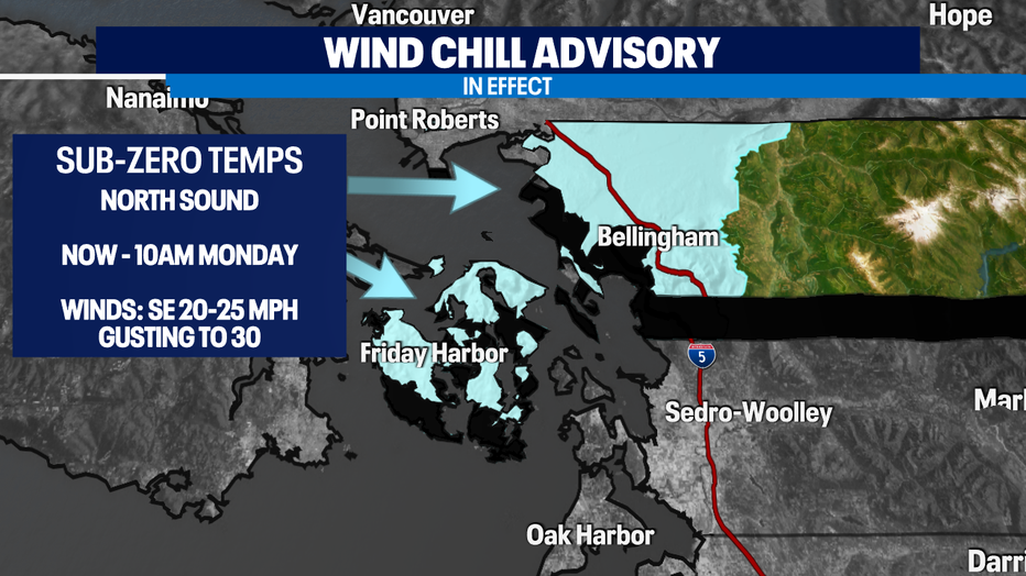
A "Wind Chill Advisory" has been issued for Western Whatcom and San Juan Counties through Monday morning with wind chills below zero! Monday morning will be cold with temps in the teens across most areas with single digits for Whatcom County.
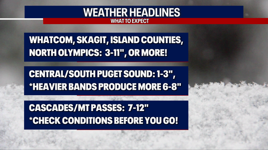
Here's a breakdown of our snow "Weather Headlines" this holiday weekend:
Best chance for higher snow accumulations in the lowlands will be the North Sound, the Islands and northern Olympics. We're forecasting 3-11" with lesser amounts, 1-3" for the Central and South Sound.
Take a look at our current snow alerts for the region:
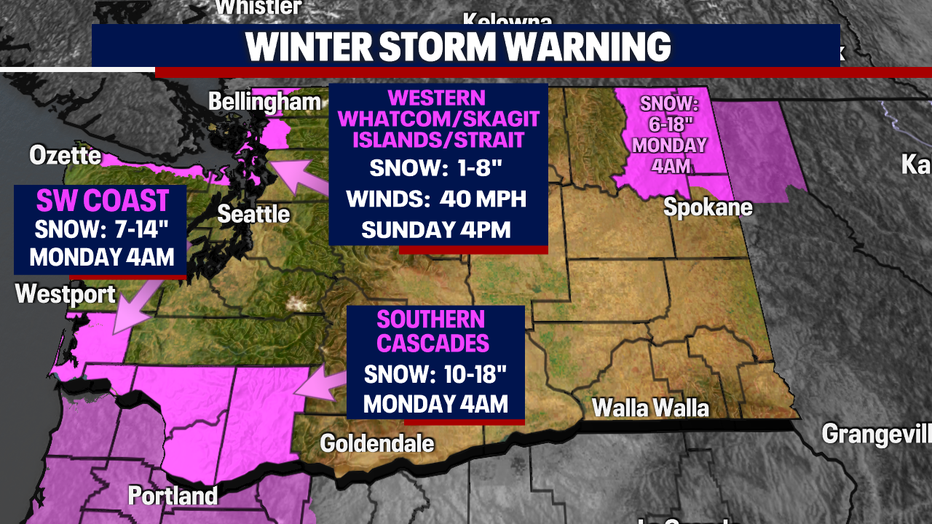
A "Winter Storm Warning" will remain in effect through Sunday about 4pm for the Strait of Juan de Fuca, including Port Angeles, Admiralty Inlet, Port Townsend, Whidbey and Camano Islands along with Western Whatcom and Skagit Counties.
The SW WA Coast along with the Southern Cascades and areas further east hold on to the storm warning a little longer through Monday at 4am.
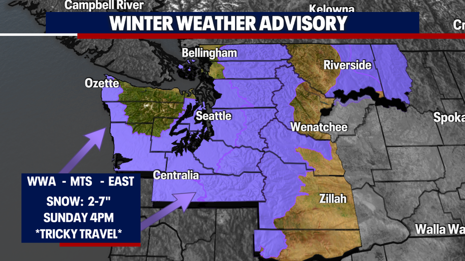
Everywhere else around the region is under a "Winter Weather Advisory" through Sunday at 4pm. As we talked about in our headlines some folks will see more snow falling than others as bands of snow showers roll through overnight. Again, travel will be difficult at times.
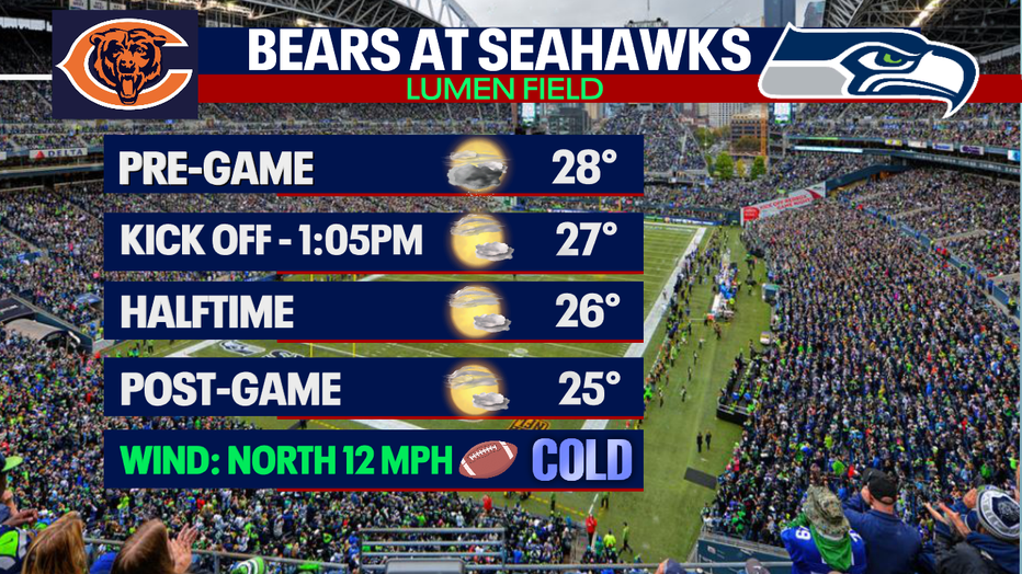
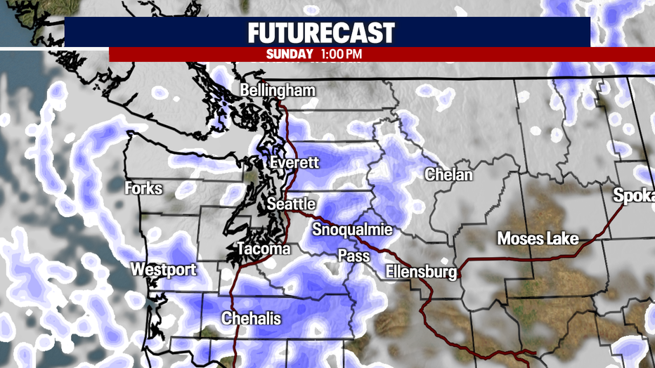
Those bands of widespread showers will take us to near kick off for the Seahawks vs Bears tomorrow at 1:05pm. Winds will be breezy at times out of the north at 12 mph. Those winds will become bone chilling though the stadium! Dress warm if you are heading out to Lumen Field. And please allow for extra time on the roads.
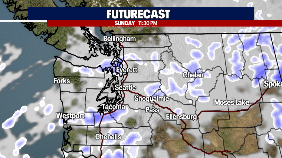
Showers taper just after 1pm tomorrow with skies clearing out a bit too. As skies clear temperatures will start to plummet again. Highs Sunday will struggle to make it to 30! And by late afternoon we're looking at mid 20s for the metro area with low 20s and teens to the north.
A few flurries will continue to fly through late Sunday night near the convergence zone in Western Snohomish County. We should completely dry out by early Monday.
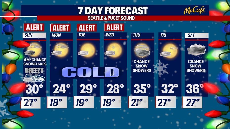
Our "Weather Alerts" will take us through mid-week as the arctic air-mass slides south keeping temperatures well below average for this time of year. Normal temperatures for the start of winter: 46/37. So, with forecasted highs in the 20s and lows in the teens through Wednesday please make sure outdoor hose bibb or spigots are covered and protected unless you have frost proof heads.
The next system will slide south along the coast on Tuesday with a chance for a few more snow showers with almost everyone inland staying dry. Accumulation will be light with about 1-2" for the coast with possible light showers for areas south and west of Kitsap County.
Precipitation moves back in late Wednesday night into Thursday as a stronger system tracks inland. This opens the door for another chance at lowland snow. With temperatures warming slightly we expect light to moderate snowfall amounts around the region. Snow will transition back to a rain/snow mix before drying out again Friday. Highs Friday land near freezing.
Saturday's system gives folks another shot at seeing a few snowflakes fly too. Highs jump a few degrees into the mid to upper 30s…. still well below the norm!
Happy Holidays All! ~Erin Mayovsky, FOX 13 Forecaster
"may" - Google News
December 26, 2021 at 12:12PM
https://ift.tt/3erFt3Y
Weather Alert: A holiday snow event may blanket Western WA with widespread showers! Snow: 2-11"+ - Q13 FOX (Seattle)
"may" - Google News
https://ift.tt/3foH8qu
https://ift.tt/2zNW3tO
Bagikan Berita Ini


0 Response to "Weather Alert: A holiday snow event may blanket Western WA with widespread showers! Snow: 2-11"+ - Q13 FOX (Seattle)"
Post a Comment