Good Wednesday bloggers,
We will be in an unseasonably cold May weather pattern the next 7 days. Highs and lows will be closer to the averages at the end of March. We will see fast-moving storm systems that bring us periods of rain and some thunderstorms. The cold weather pattern is squashing the severe weather threats. Now we still may see some hail with thunderstorms, but most severe weather will occur to the south for now. The second half of this month will see our severe weather chances increase as warmer and more humid air arrives. Let's go through this odd May weather.
This is a satellite from 11:35 AM. The clouds we had today were being caused by a small disturbance drifting south down I-29. There were a few small showers across northern and central Missouri, but this was mostly clouds. The storm we are watching for Thursday was moving through the northern Rockies Wednesday. This system will track into the northern Plains Wednesday night and then race southeast into our region Thursday before heading east-southeast into the Tennessee Valley Friday.

TONIGHT-THURSDAY MORNING: It will be mostly clear, cool and calm with lows in the 40s tonight. Thursday morning may start mostly sunny before quickly becoming cloudy. Rain may arrive around noon.

THURSDAY AFTERNOON: Rain and a few thunderstorms will be widespread across eastern Kansas and western Missouri with temperatures in the 50s. The severe threat will be located from southeast Kansas to Oklahoma and Texas where highs will reach 85-95. You can see the cold blast approaching I-80.

THURSDAY NIGHT: We will still see periods of showers and thunderstorms as the cold blast approaches. By midnight the strong cold front will be entering northern Missouri.

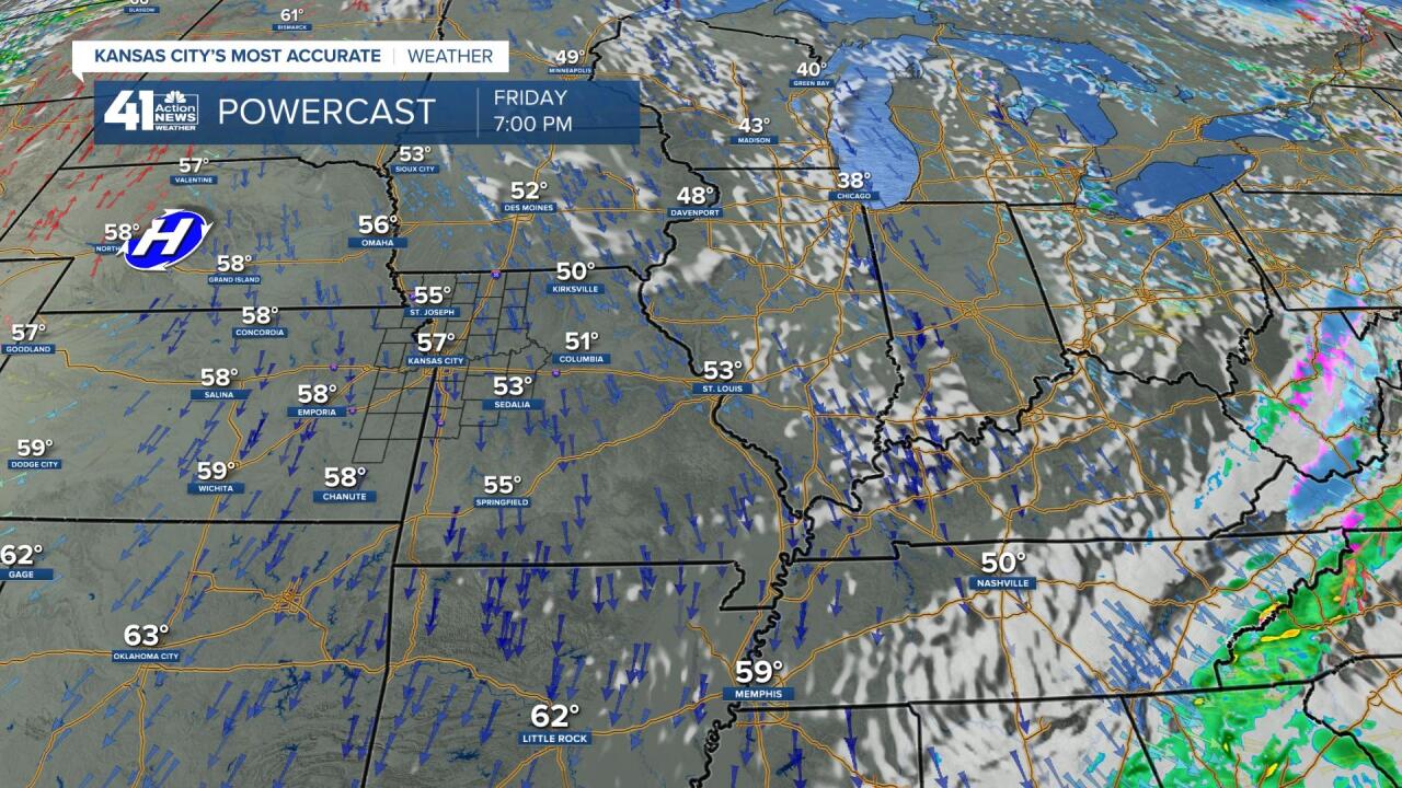
FRIDAY 2-6 AM: The cold air will be moving in on north winds 15-30 mph as we see areas of rain and drizzle. Temperatures will be in the 40s. The heavier rain and thunderstorms will be located from Texas to Indiana. Look closely at Indiana into Ohio, snow! Snow? Yes, snow and this is quite late for those locations. Our last measurable snow is May 3rd. It is a similar date for Indiana and Ohio as well.

FRIDAY MORNING: It will be windy and cool with a clearing sky. Temperatures will be in the 40s. Accumulating snow will be possible across Indiana and Ohio!

FRIDAY AFTERNOON: It will be windy and cool with highs in the 50s. The sun should be out. Now, 50s does not sound like a cold blast. But, this is a May cold blast. We are forecast to have a high of 57 which is average for March 19-21.

SATURDAY MORNING: The surface high pressure over western Nebraska will settle over head Friday night. This will drop the winds under a clear sky allowing for maximum cooling. We will see lows in the 33-40 range. The record low for Saturday is 35 set in 1980. Our last record of 32 was May 6, 2004. So, if we drop to 32 we will have the latest freeze on record. It is more likely we will be around 35 and could have a thick frost. Another low in the 30s is possible Monday. This is not great for tomato plants.

RAINFALL FORECAST THURSDAY: We will see a widespread .25" to 1". This data has the heaviest rain in a band north of KC. That heavier band could shift north or south by 20-50 miles depending on the track of any thunderstorms.

Have a great rest of your week and weekend. Stay healthy.
"may" - Google News
May 07, 2020 at 04:30AM
https://ift.tt/2SJk6kc
Weather Blog: More Like the End of March, Not Early May - KSHB
"may" - Google News
https://ift.tt/3foH8qu
https://ift.tt/2zNW3tO
Bagikan Berita Ini


0 Response to "Weather Blog: More Like the End of March, Not Early May - KSHB"
Post a Comment